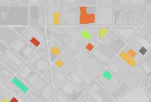
Mapping every high-rise apartment building in Seattle
We have been visiting Seattle regularly for the last two years, and it’s always impressive to watch the new development downtown progress. In particular there appear to be many new high-rise apartment buildings. We’re going to be moving to Seattle next year and are interested in these sorts of apartments. I thought I’d take a look at the state of the market and what’s available where.
I began by visiting a few apartment listing websites. Unfortunately these sites are designed around currently available units and don’t have many filters for building attributes. I wanted a simple list of all the high-rise apartment buildings in the city.
The solution was to make the list myself. The parameters are simple: all apartment buildings over 12 stories tall (an arbitrary cut-off) in Seattle. I did not include condos. One bedroom prices are for units that have a bedroom, not a partially partitioned space that are marketed as “urban” one bedrooms. I did not include pricing for any units marketed as penthouses, as this would throw off the price ranges. The dataset was collected in October 2024.
Because I compiled the dataset by hand (explained in more detail below) it’s possible I’ve missed a few smaller buildings around the 12 story cut-off. But this dataset should include all the major buildings.
Collecting the data
To locate apartment buildings, I went over a map of Seattle block-by-block and noted down all the apartments that were located in tall buildings. This was not an automated process; it consisted of me looking at satellite imagery picking out the tallish buildings. I then looked up each building’s website and collected information about its amenities and pricing, in addition to the Google Maps link and rating. To find the number of units and year built, I referred to a dataset of all residential building permits issued in Seattle since 1990. Once I’d hand collected all the buildings, I wrote a script to rank them based on their ratings both within neighborhoods and citywide.
I considered a more automated approach to locating apartments. OpenStreetMap does tag buildings with building=apartments. The challenge with using OpenStreetMap data is that most buildings don’t include the height or number of levels attributes, so it would require going through the list of all apartment buildings in Seattle one by one and somehow checking how high they are. I figured it would be faster to visually locate tall buildings, then verify if they’re apartments.
I’m sure there would have been a way to work with the Google Maps API to get this data, though I didn’t look into it.
You can download the CSV file of the apartment buildings and their attributes here. Use it however you’d like. It’s a snapshot in time and may contain inaccurate information.
Building the map
After I’d created a spreadsheet of the apartment buildings, I wanted to identify the buildings on a map. The building permit dataset included a latitude and longitude for each building, so I added that for each building in the dataset.
Next I downloaded geographic information for all buildings in Seattle from OpenStreetMap with the Overpass API. I wrote a script to convert the OSM data to a GeoJSON file of polygon features. The apartment buildings could then be identified by checking which polygon each point was located within.
The basemap is an extract of the protomaps basemap. The map is rendered with MapLibre GL JS.
⁂
